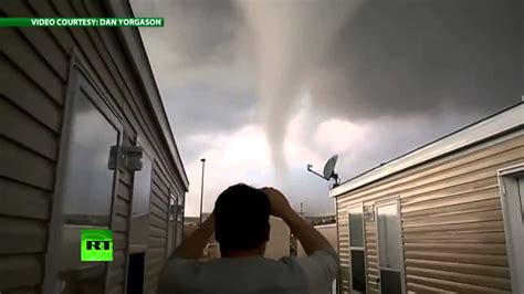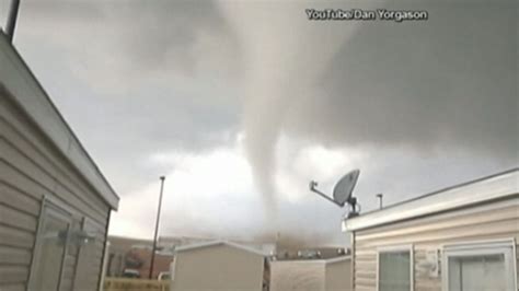
A powerful tornado tore through North Dakota on Monday, leaving behind a trail of destruction and capturing the attention of meteorologists and storm chasers alike. Dramatic footage of the twister, swirling violently across the open landscape, has emerged, showcasing the raw power of nature and prompting renewed discussions about severe weather preparedness in the region.
Intense video footage captured a significant tornado as it touched down in North Dakota on Monday, May 6, 2024. The dramatic scenes, widely circulated online, show the large, rotating column of air churning across open fields, highlighting the sheer force and potential danger of such weather events. While initial reports suggest damage was primarily limited to rural areas, the event serves as a stark reminder of the vulnerability of communities in the path of severe storms and the importance of heeding weather warnings. The National Weather Service is currently assessing the tornado’s strength and path to determine its official rating on the Enhanced Fujita (EF) scale.
The tornado was sighted in an area with low population density, which likely mitigated potential widespread damage and casualties. However, the visual impact of the event, documented in numerous videos and photographs, underscores the destructive capability of tornadoes and the need for robust early warning systems and public awareness campaigns.
Meteorologists are analyzing data from the event to understand the specific atmospheric conditions that led to the tornado’s formation. This analysis will contribute to improved forecasting models and a better understanding of severe weather patterns in the region. The National Weather Service had issued tornado watches and warnings for parts of North Dakota on Monday, prompting residents to seek shelter.
The footage of the North Dakota tornado has quickly spread across social media platforms, generating widespread discussion and concern. Many users have expressed awe at the power of the storm while also highlighting the importance of preparedness and safety measures during severe weather events. The event has also prompted renewed calls for increased investment in weather forecasting technology and public education programs to help communities better prepare for and respond to tornadoes and other extreme weather phenomena.
According to reports, there were no immediate reports of serious injuries or fatalities. However, the extent of property damage is still being assessed. Emergency response teams are on the ground, working to ensure the safety of residents and to provide assistance to those affected by the storm. The event serves as a reminder of the unpredictable nature of severe weather and the importance of taking necessary precautions to protect lives and property.
The sighting of this tornado emphasizes the need for continued vigilance and preparedness, especially during peak tornado season. Local authorities are urging residents to stay informed about weather conditions and to take shelter immediately if a tornado warning is issued.
The North Dakota tornado serves as a powerful reminder of the destructive potential of severe weather and the importance of preparedness. While the immediate impact appears to have been limited due to the storm’s path through sparsely populated areas, the event underscores the need for ongoing investment in weather forecasting technology, public education, and emergency response capabilities.
Further Details and Context
The recent tornado in North Dakota is part of a broader pattern of severe weather events that have been occurring across the United States in recent years. Climate change is believed to be a contributing factor to the increased frequency and intensity of these events, although the precise relationship between climate change and tornado activity is still an area of ongoing research.
Tornadoes are formed from powerful thunderstorms, known as supercells, which contain rotating columns of air called mesocyclones. Under the right atmospheric conditions, the mesocyclone can tighten and descend, eventually touching the ground as a tornado. The strength of a tornado is measured using the Enhanced Fujita (EF) scale, which ranges from EF0 (weakest) to EF5 (strongest). The EF scale is based on the damage caused by the tornado, with higher ratings indicating more severe damage.
The area where the tornado struck in North Dakota is part of the Great Plains region, which is known as “Tornado Alley” due to its high frequency of tornadoes. The unique geography and atmospheric conditions of the Great Plains, including its flat terrain and colliding air masses, make it particularly susceptible to tornado formation.
The National Weather Service plays a crucial role in monitoring and forecasting severe weather events, including tornadoes. The agency uses a combination of radar, satellite imagery, and ground-based observations to detect and track thunderstorms and to issue tornado watches and warnings. A tornado watch means that conditions are favorable for tornadoes to develop in the area, while a tornado warning means that a tornado has been sighted or indicated by radar and poses an imminent threat.
When a tornado warning is issued, it is crucial for residents to take immediate shelter. The safest place to be during a tornado is in a basement, storm cellar, or interior room on the lowest floor of a sturdy building. It is important to stay away from windows, doors, and outside walls. If you are in a car or mobile home, you should abandon it and seek shelter in a more substantial building.
The aftermath of a tornado can be devastating, with widespread damage to homes, businesses, and infrastructure. Emergency response teams play a critical role in providing assistance to affected communities, including search and rescue operations, medical care, and the distribution of food and supplies. Insurance companies also play a key role in helping residents recover from the financial losses caused by tornadoes.
The recent tornado in North Dakota highlights the importance of preparedness and resilience in the face of severe weather events. By staying informed about weather conditions, taking shelter when necessary, and supporting efforts to improve forecasting and emergency response capabilities, communities can better protect themselves from the devastating impacts of tornadoes.
Detailed Analysis of the Meteorological Conditions
To understand the formation of the North Dakota tornado, a closer examination of the meteorological conditions present on May 6, 2024, is essential. The key ingredients for severe thunderstorm and tornado development include instability, wind shear, and lift.
-
Instability: This refers to the atmosphere’s tendency to resist or encourage vertical motion. In the case of the North Dakota event, there was likely a significant amount of instability present, characterized by warm, moist air near the surface and cooler air aloft. This creates a situation where air parcels, if lifted, will continue to rise rapidly, fueling thunderstorm development. Meteorologists often use indices such as CAPE (Convective Available Potential Energy) to measure instability. High CAPE values indicate a greater potential for strong thunderstorms.
-
Wind Shear: Wind shear is the change in wind speed and/or direction with height. It is a crucial ingredient for the development of rotating thunderstorms, or supercells. In the North Dakota case, strong wind shear was likely present, with winds increasing and changing direction with altitude. This wind shear can cause the thunderstorm updraft to rotate, forming a mesocyclone – a rotating column of air within the thunderstorm. The stronger the wind shear, the greater the potential for a strong and long-lived mesocyclone, and thus, a greater risk of tornadoes.
-
Lift: Lift is the force that initiates the upward motion of air parcels, triggering thunderstorm development. This can be caused by various factors, such as fronts, drylines, or terrain features. In the North Dakota event, a weather front or dryline may have provided the necessary lift to initiate thunderstorm development. Once thunderstorms form, the release of latent heat from condensation further enhances the updraft, leading to the development of severe weather.
By analyzing weather models, radar data, and satellite imagery, meteorologists can reconstruct the atmospheric conditions that led to the formation of the North Dakota tornado. This analysis can help improve forecasting models and provide more accurate warnings in the future.
Community Impact and Response
While the tornado primarily impacted rural areas, the psychological impact on the community should not be underestimated. Even those who were not directly affected may experience anxiety and fear, especially during subsequent severe weather events. It is crucial for local authorities and mental health professionals to provide support and counseling services to help residents cope with the emotional aftermath of the tornado.
The response to the tornado involved a coordinated effort from various agencies, including local law enforcement, fire departments, emergency medical services, and the National Weather Service. These agencies worked together to assess the damage, provide assistance to those in need, and ensure the safety of the community.
Volunteers also played a crucial role in the response effort, providing assistance with cleanup, debris removal, and the distribution of food and supplies. The outpouring of support from the community highlights the resilience and compassion of the people of North Dakota.
The Role of Social Media
Social media played a significant role in the coverage of the North Dakota tornado. Videos and photographs of the tornado quickly spread across platforms such as Twitter, Facebook, and YouTube, providing real-time updates and visual documentation of the event.
Social media can be a valuable tool for disseminating information during severe weather events. However, it is also important to be aware of the potential for misinformation and to verify information from trusted sources before sharing it. The National Weather Service and local news outlets are reliable sources of information during severe weather events.
Preparing for Future Tornadoes
The North Dakota tornado serves as a reminder of the importance of being prepared for future severe weather events. Here are some steps that residents can take to protect themselves and their families:
- Stay Informed: Monitor weather forecasts and alerts from the National Weather Service and local news outlets.
- Develop a Plan: Create a family emergency plan that includes a designated meeting place and a plan for communication.
- Build a Kit: Assemble an emergency kit that includes food, water, medications, a first-aid kit, a flashlight, and a battery-powered radio.
- Know Where to Take Shelter: Identify the safest place to take shelter in your home, such as a basement, storm cellar, or interior room on the lowest floor.
- Practice Drills: Conduct regular tornado drills to ensure that everyone in your family knows what to do in the event of a tornado warning.
- Consider a Safe Room: If you live in an area that is prone to tornadoes, consider building a safe room or storm shelter.
By taking these steps, residents can increase their chances of survival and minimize the impact of future tornadoes.
Impact on Infrastructure and Agriculture
While initial reports suggest limited widespread damage, the impact on local infrastructure and agriculture needs further evaluation. Even in rural areas, tornadoes can damage power lines, communication towers, and transportation networks, disrupting essential services and hindering rescue efforts.
Agricultural lands are particularly vulnerable to tornadoes. The strong winds can destroy crops, damage farm buildings, and injure or kill livestock. The economic impact on local farmers can be significant, especially if the tornado occurs during a critical stage of crop development.
A thorough assessment of the damage to infrastructure and agriculture is essential to determine the extent of the economic impact and to develop strategies for recovery and rebuilding.
The Enhanced Fujita (EF) Scale
The Enhanced Fujita (EF) Scale is used to rate the intensity of tornadoes based on the damage they cause. It is an updated version of the original Fujita Scale, which was developed by Dr. Tetsuya Theodore “Ted” Fujita in 1971. The EF Scale takes into account a wider range of damage indicators and provides more accurate estimates of wind speeds.
The EF Scale ranges from EF0 to EF5, with each level corresponding to a range of estimated wind speeds and expected damage.
- EF0: Weak tornado with estimated wind speeds of 65-85 mph. Damage is typically light, such as broken branches, damaged signs, and minor roof damage.
- EF1: Weak tornado with estimated wind speeds of 86-110 mph. Damage is moderate, such as peeled roofing, broken windows, and overturned mobile homes.
- EF2: Strong tornado with estimated wind speeds of 111-135 mph. Damage is considerable, such as roofs torn off well-constructed houses, uprooted trees, and cars lifted off the ground.
- EF3: Strong tornado with estimated wind speeds of 136-165 mph. Damage is severe, such as entire stories of well-built houses destroyed, significant damage to large buildings, and cars thrown considerable distances.
- EF4: Violent tornado with estimated wind speeds of 166-200 mph. Damage is devastating, such as well-built houses leveled, cars turned into projectiles, and trees debarked.
- EF5: Violent tornado with estimated wind speeds of over 200 mph. Damage is incredible, with complete destruction of everything in its path, including well-built houses swept away, and large structures disintegrated.
The National Weather Service uses the EF Scale to assess the intensity of tornadoes after they occur, based on the damage they have caused. This information is used to improve our understanding of tornadoes and to refine forecasting models.
Long-Term Implications and Future Research
The North Dakota tornado, while seemingly isolated in its impact due to its rural path, has broader implications for understanding severe weather patterns and improving forecasting accuracy. Further research is needed to:
-
Improve Tornado Prediction Models: While forecasting technology has advanced significantly, predicting the precise location and intensity of tornadoes remains a challenge. Continued research is needed to improve the accuracy of tornado prediction models, particularly in regions like the Great Plains, where tornadoes are common. This includes incorporating more detailed atmospheric data and developing more sophisticated algorithms.
-
Study the Impact of Climate Change on Tornado Activity: The relationship between climate change and tornado activity is complex and not fully understood. Some studies suggest that climate change may lead to an increase in the frequency and intensity of severe thunderstorms, which could potentially increase the risk of tornadoes. However, other factors, such as changes in wind patterns and atmospheric stability, could also influence tornado activity. More research is needed to understand the complex interactions between climate change and tornadoes.
-
Enhance Public Awareness and Preparedness: Despite the efforts of the National Weather Service and other organizations, many people still do not fully understand the risks associated with tornadoes or how to prepare for them. Public awareness campaigns are needed to educate people about tornado safety and to encourage them to take steps to protect themselves and their families. This includes providing information about tornado shelters, emergency kits, and warning systems.
-
Develop More Resilient Infrastructure: Tornadoes can cause significant damage to infrastructure, disrupting essential services and hindering rescue efforts. Efforts are needed to develop more resilient infrastructure that can withstand the forces of tornadoes. This includes building stronger buildings, burying power lines, and developing backup communication systems.
The North Dakota tornado serves as a reminder of the importance of ongoing research and preparedness efforts to mitigate the risks associated with severe weather events.
Frequently Asked Questions (FAQ)
- What caused the tornado in North Dakota?
The tornado was likely caused by a combination of factors, including atmospheric instability (warm, moist air near the surface and cooler air aloft), strong wind shear (changes in wind speed and/or direction with height), and lift (a mechanism to initiate the upward motion of air parcels, such as a front or dryline). These conditions created a rotating thunderstorm called a supercell, which eventually spawned a tornado.
- How strong was the tornado?
The National Weather Service is currently assessing the tornado’s strength and path to determine its official rating on the Enhanced Fujita (EF) scale. The EF scale ranges from EF0 (weakest) to EF5 (strongest), based on the damage caused by the tornado.
- Where did the tornado occur?
The tornado occurred in North Dakota on Monday, May 6, 2024. Initial reports suggest it impacted primarily rural areas.
- Were there any injuries or fatalities?
According to initial reports, there were no immediate reports of serious injuries or fatalities. However, the extent of property damage is still being assessed.
- What should I do if a tornado warning is issued in my area?
If a tornado warning is issued, seek shelter immediately. The safest place to be is in a basement, storm cellar, or interior room on the lowest floor of a sturdy building. Stay away from windows, doors, and outside walls. If you are in a car or mobile home, abandon it and seek shelter in a more substantial building.
Examining Past Tornado Events in North Dakota
To gain a deeper understanding of the context of the recent North Dakota tornado, it is helpful to examine past tornado events in the state. North Dakota, while not as frequently impacted as states further south in “Tornado Alley,” still experiences its share of severe weather, including tornadoes.
Historically, North Dakota has seen a number of significant tornado events, some of which have caused considerable damage and even loss of life. Records from the National Weather Service and the Storm Prediction Center provide data on the frequency, intensity, and paths of past tornadoes in the state.
Analyzing these historical events can reveal patterns and trends in tornado activity, such as the areas that are most vulnerable, the times of year when tornadoes are most likely to occur, and the types of atmospheric conditions that are most conducive to tornado formation. This information can be used to improve forecasting models, enhance public awareness, and develop more effective preparedness strategies.
Furthermore, studying past tornado events can help identify areas where infrastructure is particularly vulnerable and where improvements are needed to enhance resilience. This can inform decisions about building codes, land-use planning, and emergency management.
By learning from the past, communities in North Dakota can better prepare for future tornado events and minimize their impact.
The Economic Impact of Tornadoes
The economic impact of tornadoes can be significant, affecting individuals, businesses, and communities. The costs associated with tornadoes include:
- Property Damage: Tornadoes can cause extensive damage to homes, businesses, and other structures. The cost of repairing or rebuilding these structures can be substantial.
- Crop Losses: Tornadoes can destroy crops, leading to significant financial losses for farmers.
- Business Interruption: Tornadoes can disrupt business operations, leading to lost revenue and productivity.
- Infrastructure Damage: Tornadoes can damage power lines, communication towers, and transportation networks, disrupting essential services and hindering economic activity.
- Emergency Response Costs: The costs associated with emergency response efforts, such as search and rescue operations, medical care, and the distribution of food and supplies, can be significant.
- Insurance Costs: Tornadoes can lead to increased insurance premiums for homeowners and businesses.
The overall economic impact of a tornado depends on its intensity, path, and the density of population and economic activity in the affected area. Major tornadoes that strike densely populated areas can cause billions of dollars in damage.
Efforts to mitigate the economic impact of tornadoes include:
- Building Codes: Implementing and enforcing stricter building codes can help ensure that structures are better able to withstand the forces of tornadoes.
- Land-Use Planning: Careful land-use planning can help minimize the risk of damage from tornadoes by avoiding development in areas that are particularly vulnerable.
- Insurance Coverage: Encouraging homeowners and businesses to purchase adequate insurance coverage can help them recover from the financial losses caused by tornadoes.
- Disaster Relief Programs: Providing access to disaster relief programs can help individuals and communities recover from the economic impact of tornadoes.
The Psychological Impact of Tornadoes
Beyond the physical and economic impacts, tornadoes can also have a significant psychological impact on those who experience them. The stress and trauma associated with witnessing or being affected by a tornado can lead to a range of mental health problems, including:
- Anxiety: Tornadoes can trigger feelings of anxiety and fear, particularly in individuals who have previously experienced a tornado or other traumatic event.
- Depression: The loss of property, livelihood, or loved ones can lead to feelings of sadness and hopelessness, which can develop into depression.
- Post-Traumatic Stress Disorder (PTSD): Some individuals who experience tornadoes may develop PTSD, a mental health condition that is characterized by flashbacks, nightmares, and intrusive thoughts.
- Sleep Disturbances: The stress and anxiety associated with tornadoes can disrupt sleep patterns, leading to insomnia and other sleep disturbances.
- Grief: The loss of property, livelihood, or loved ones can lead to feelings of grief and bereavement.
The psychological impact of tornadoes can be long-lasting and can affect individuals of all ages. It is important for communities to provide access to mental health services to help those who have been affected by tornadoes cope with their emotions and recover from the trauma.
Mental health professionals can provide counseling, therapy, and other interventions to help individuals manage their anxiety, depression, PTSD, and other mental health problems. Support groups can also provide a valuable source of comfort and support for those who have experienced tornadoes.
Future of Tornado Forecasting
The future of tornado forecasting is likely to be driven by advances in technology and scientific understanding. Some of the key areas of development include:
- Improved Radar Technology: Next-generation radar systems, such as phased-array radar, offer the potential to provide more detailed and accurate information about thunderstorms, allowing for earlier and more precise tornado warnings.
- Advanced Computer Modeling: Supercomputers are being used to develop more sophisticated weather models that can simulate the atmosphere in greater detail, allowing for more accurate predictions of tornado formation.
- Data Assimilation Techniques: New data assimilation techniques are being developed to incorporate a wider range of data sources into weather models, including satellite imagery, ground-based observations, and even social media reports.
- Artificial Intelligence and Machine Learning: Artificial intelligence and machine learning are being used to analyze vast amounts of weather data and identify patterns that may be indicative of tornado formation.
- Mobile Technology: Mobile apps and other mobile technologies are being used to disseminate weather warnings and safety information to the public in a timely and effective manner.
These advances in technology and scientific understanding hold the promise of improving tornado forecasting accuracy and reducing the risk of injury and death from these destructive storms.
By continuously investing in research and development, and by working collaboratively across government, academia, and the private sector, we can continue to improve our ability to forecast tornadoes and protect communities from their devastating impacts.
The North Dakota tornado serves as a stark reminder of the power of nature and the importance of preparedness. While the immediate impact appears to have been limited, the event underscores the need for ongoing vigilance, investment in research and technology, and a commitment to public education and safety.