A rare and powerful tornado was captured on video swirling across the North Dakota landscape on Monday, shocking residents and meteorologists alike with its intensity and scale. The twister, described as “intense” by weather experts, prompted widespread concern, though initial reports indicate limited structural damage and no reported injuries.
North Dakota Struck by Rare, Powerful Tornado
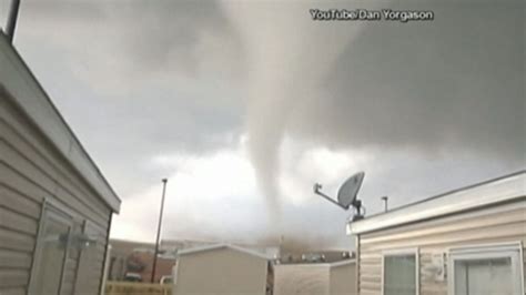
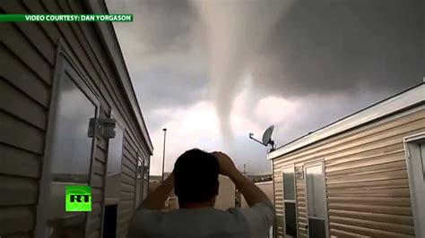
A powerful tornado touched down in North Dakota on Monday, leaving residents in awe and weather experts analyzing the unusual event. Dramatic video footage of the large twister quickly spread across social media, showcasing its immense size and swirling vortex as it moved across open fields. While the tornado raised immediate concerns about potential damage, initial reports suggest limited structural impact and, remarkably, no reported injuries.
The National Weather Service (NWS) issued tornado warnings for several counties in the region as the storm system moved through, urging residents to seek shelter immediately. The tornado was observed near Watford City, a city in McKenzie County, but its exact path and duration are still being assessed by weather officials.
“It was intense,” one local resident told news outlets, describing the sight of the tornado as both terrifying and mesmerizing. The video footage corroborates these accounts, showing a large, well-defined tornado with a visible condensation funnel extending from the cloud base to the ground.
The occurrence of such a strong tornado in North Dakota is relatively rare, although not unprecedented. The state lies on the northern edge of Tornado Alley, a region in the central United States known for its frequent and severe tornado activity. However, the intensity and size of Monday’s tornado have prompted meteorologists to examine the atmospheric conditions that contributed to its formation.
According to the NWS, the storm system responsible for the tornado developed rapidly due to a combination of factors, including warm, moist air moving northward from the Gulf of Mexico and colliding with a cold front pushing eastward from the Rocky Mountains. This clash of air masses created the instability and shear necessary for the development of severe thunderstorms and tornadoes.
The tornado’s appearance also coincided with a period of heightened atmospheric instability across the Great Plains, with several other states also experiencing severe weather, including large hail, damaging winds, and isolated tornadoes.
The aftermath of the tornado is still being assessed, with local authorities conducting damage surveys to determine the full extent of the impact. While initial reports suggest limited structural damage, the tornado’s powerful winds may have caused damage to trees, power lines, and agricultural infrastructure.
The event serves as a stark reminder of the destructive potential of severe weather and the importance of heeding weather warnings. The NWS urges residents in tornado-prone areas to have a plan in place, including a designated safe room or shelter, and to stay informed about weather conditions through reliable sources such as the NWS website and local media outlets.
The North Dakota tornado is likely to fuel further research into the factors that contribute to tornado formation and intensity, particularly in regions where such events are less common. Meteorologists will be analyzing the atmospheric data to better understand the conditions that led to the tornado’s development and to improve forecasting models for future severe weather events.
Expert Analysis and Meteorological Context
The North Dakota tornado, while shocking in its visual impact, highlights the complex interplay of atmospheric conditions that can lead to the formation of these destructive weather phenomena. Meteorologists are currently examining data from weather satellites, radar systems, and surface observations to reconstruct the tornado’s life cycle and understand the factors that contributed to its unusual strength.
One key factor is the presence of strong wind shear, which refers to changes in wind speed and direction with height. Wind shear can create a rotating column of air near the ground, known as a horizontal vortex. If a thunderstorm develops in an environment with strong wind shear, the updraft of the storm can tilt the horizontal vortex vertically, forming a rotating supercell thunderstorm, which is the type of storm most likely to produce tornadoes.
Another important factor is atmospheric instability, which refers to the tendency of air to rise rapidly. Instability is created when warm, moist air near the surface is overlain by cooler, drier air aloft. The greater the temperature difference between the surface air and the air aloft, the greater the instability and the stronger the potential for thunderstorm development.
In the case of the North Dakota tornado, the combination of strong wind shear and high atmospheric instability created a favorable environment for the formation of a supercell thunderstorm capable of producing a large and powerful tornado.
“The atmosphere was primed for severe weather,” explained Dr. Emily Fischer, a meteorologist with the University of Colorado. “We had a potent combination of warm, moist air from the Gulf of Mexico surging northward, interacting with a strong cold front. This created a highly unstable environment with plenty of wind shear, which is the recipe for supercell thunderstorms and tornadoes.”
The location of North Dakota on the northern fringe of Tornado Alley also plays a role in the rarity of such strong tornadoes. While tornadoes can occur in any state, they are most frequent and intense in the central United States, where the conditions are most favorable for their formation. However, as climate patterns shift, it is possible that tornado activity could become more common in regions that have historically experienced fewer tornadoes.
Impact and Response
While initial reports indicate limited structural damage from the North Dakota tornado, the potential for more widespread damage was certainly present. The tornado’s path through open fields likely mitigated the impact on populated areas, but the powerful winds could have easily caused significant damage to buildings, vehicles, and infrastructure.
Local authorities and emergency responders were quick to respond to the event, issuing warnings to residents and conducting damage assessments in the affected areas. The NWS played a crucial role in providing timely and accurate weather information, allowing residents to take necessary precautions and seek shelter.
“Our priority is always to protect life and property,” said Sarah Johnson, a spokesperson for the North Dakota Department of Emergency Services. “We worked closely with the National Weather Service to issue timely warnings and ensure that residents were aware of the potential danger. We are grateful that there were no reported injuries as a result of the tornado.”
The response to the North Dakota tornado highlights the importance of preparedness and collaboration in mitigating the impact of severe weather events. Having a plan in place, staying informed about weather conditions, and heeding warnings from authorities can significantly reduce the risk of injury or death during a tornado.
The Role of Climate Change
The occurrence of the North Dakota tornado has also raised questions about the potential role of climate change in altering tornado patterns. While it is difficult to attribute any single tornado event to climate change, scientists are increasingly studying the potential impacts of a warming climate on severe weather.
Some studies suggest that climate change could lead to an increase in the frequency and intensity of severe thunderstorms, which could, in turn, lead to more tornadoes. However, the relationship between climate change and tornadoes is complex and not fully understood.
One of the challenges in studying the impact of climate change on tornadoes is the limited historical data. Tornado records are often incomplete, particularly for tornadoes that occur in rural areas or before the widespread use of radar technology. This makes it difficult to detect long-term trends in tornado activity.
Despite these challenges, scientists are using climate models and statistical analysis to investigate the potential impacts of climate change on tornadoes. Some models suggest that climate change could lead to a shift in the geographic distribution of tornadoes, with some areas experiencing more tornadoes and others experiencing fewer.
“The science is still evolving, but there is growing evidence that climate change could be influencing severe weather patterns,” said Dr. David Thompson, a climate scientist at the University of Washington. “We need to continue to invest in research to better understand these complex interactions and to improve our ability to forecast severe weather in a changing climate.”
Lessons Learned and Future Preparedness
The North Dakota tornado serves as a reminder of the importance of preparedness for severe weather events, even in regions where such events are relatively rare. Residents in tornado-prone areas should have a plan in place, including a designated safe room or shelter, and should stay informed about weather conditions through reliable sources.
The NWS plays a critical role in providing timely and accurate weather information, but it is up to individuals and communities to take action based on that information. This includes heeding warnings, seeking shelter when necessary, and taking steps to protect property.
In addition to individual preparedness, communities should also invest in infrastructure improvements that can help to mitigate the impact of severe weather events. This includes building stronger buildings, improving drainage systems, and developing emergency response plans.
“We need to learn from every severe weather event and use that knowledge to improve our preparedness for the future,” said Mayor Patricia Miller of Watford City. “The North Dakota tornado was a wake-up call for our community, and we are committed to taking steps to protect our residents from future severe weather events.”
The North Dakota tornado, while a rare and powerful event, provides valuable lessons about the importance of preparedness, the complexity of atmospheric processes, and the potential impacts of climate change. By understanding these lessons, we can better protect ourselves and our communities from the risks posed by severe weather.
Frequently Asked Questions (FAQ)
-
How rare are tornadoes in North Dakota? While North Dakota is not considered a primary region for tornadoes like those in “Tornado Alley,” they do occur. Strong tornadoes, like the one observed, are less frequent but not unprecedented. The state experiences an average of 25 tornadoes per year.
-
Was anyone injured or killed in the North Dakota tornado? According to initial reports, and remarkably, there were no reported injuries or fatalities as a result of the tornado. This is largely attributed to the tornado primarily tracking across open fields.
-
What caused this tornado to form? The tornado formed due to a combination of atmospheric conditions, including strong wind shear (changes in wind speed and direction with height), high atmospheric instability (warm, moist air near the surface overlain by cooler, drier air aloft), and the presence of a strong cold front interacting with warm, moist air from the Gulf of Mexico.
-
How strong was the tornado? An official EF-scale rating has yet to be assigned; however, based on video evidence and initial reports, the tornado was significant. The National Weather Service will conduct damage surveys to determine the tornado’s strength, assessing damage to structures and vegetation along its path.
-
Is climate change influencing tornado activity in North Dakota? The relationship between climate change and tornado activity is complex and still under study. While it is difficult to attribute a single tornado to climate change, some research suggests that a warming climate could potentially alter severe weather patterns, possibly leading to shifts in tornado frequency and intensity in different regions. More data and research are needed to establish definitive links.
Expanded Analysis of the Tornado’s Formation
Delving deeper into the meteorological aspects of the North Dakota tornado, the event underscores the significance of mesoscale meteorology – the study of weather phenomena ranging in size from a few kilometers to several hundred kilometers. These mesoscale systems are often the driving force behind severe weather outbreaks, and understanding their dynamics is crucial for accurate forecasting.
In this specific instance, a mesoscale convective system (MCS) – a complex of thunderstorms that acts as a single, organized entity – played a pivotal role. The MCS developed along the aforementioned cold front, drawing in warm, moist air from the Gulf of Mexico. This influx of moisture, combined with the lifting mechanism provided by the front, created a highly unstable environment conducive to thunderstorm development.
Furthermore, the presence of a low-level jet stream – a concentrated band of strong winds near the surface – contributed to the enhanced wind shear in the region. This low-level jet not only provided the necessary rotation for tornado formation but also helped to transport warm, moist air northward, further fueling the storm.
The interaction between the MCS and the terrain may have also played a role in the tornado’s development. While North Dakota is generally flat, subtle variations in elevation and land use can influence airflow and enhance convergence – the coming together of air masses. This convergence can trigger localized areas of upward motion, which can then initiate or intensify thunderstorms.
The role of capping inversions – layers of warm air aloft that inhibit thunderstorm development – should also be considered. These inversions can act as a lid on the atmosphere, preventing thunderstorms from forming until sufficient energy builds up to break through the cap. In this case, it is possible that a strong capping inversion initially suppressed thunderstorm development, allowing for a greater build-up of energy before the MCS finally erupted.
The Importance of Public Awareness and Preparedness
The North Dakota tornado serves as a critical reminder of the importance of public awareness and preparedness for severe weather events, regardless of geographic location. The rapid dissemination of information through social media played a crucial role in alerting residents to the approaching danger, but it also highlights the need for reliable and accurate sources of information.
The National Weather Service’s role in issuing timely warnings cannot be overstated. These warnings provide critical information about the location, intensity, and potential impact of severe weather events, allowing residents to take appropriate precautions. However, the effectiveness of these warnings depends on residents’ ability to receive and understand them.
To improve public awareness, communities should invest in education and outreach programs that teach residents about the risks of severe weather and how to prepare for them. These programs should cover topics such as tornado safety, flood safety, and preparedness for other types of hazardous weather.
In addition to education, communities should also invest in infrastructure improvements that can enhance preparedness. This includes building stronger buildings, improving communication systems, and developing evacuation plans.
The use of technology can also play a significant role in improving preparedness. Mobile apps, social media platforms, and other digital tools can be used to disseminate weather information quickly and efficiently. These tools can also be used to collect and share information from the public, providing valuable situational awareness to emergency responders.
The Economic and Social Impacts of Tornadoes
Tornadoes can have significant economic and social impacts on communities, ranging from damage to property and infrastructure to disruptions to businesses and displacement of residents. The economic costs of tornadoes can be substantial, including the cost of repairing or replacing damaged buildings, cleaning up debris, and providing assistance to affected individuals and businesses.
The social impacts of tornadoes can also be profound, including emotional distress, psychological trauma, and the disruption of social networks. Tornadoes can also exacerbate existing social inequalities, disproportionately affecting vulnerable populations such as low-income families, elderly individuals, and people with disabilities.
To mitigate the economic and social impacts of tornadoes, communities should invest in mitigation measures that reduce the risk of damage and loss. These measures include building codes that require stronger buildings, land-use planning that avoids development in high-risk areas, and public education campaigns that promote preparedness.
In the aftermath of a tornado, communities should provide assistance to affected individuals and businesses, including financial assistance, housing assistance, and mental health services. They should also work to rebuild damaged infrastructure and restore social networks.
Future Research Directions
The North Dakota tornado highlights the need for continued research into the formation, behavior, and impacts of tornadoes. This research should focus on improving forecasting models, developing better warning systems, and understanding the potential impacts of climate change on tornado activity.
One key area of research is the development of better forecasting models. These models should be able to predict the formation and intensity of tornadoes with greater accuracy and lead time. This requires a better understanding of the atmospheric processes that lead to tornado formation, as well as improved data assimilation techniques that can incorporate real-time observations into the models.
Another important area of research is the development of better warning systems. These systems should be able to provide timely and accurate warnings to residents in affected areas. This requires the development of more sophisticated radar technologies that can detect tornadoes earlier, as well as improved communication systems that can disseminate warnings quickly and efficiently.
Finally, research is needed to understand the potential impacts of climate change on tornado activity. This requires the use of climate models and statistical analysis to investigate how changes in temperature, humidity, and wind patterns could affect the frequency, intensity, and geographic distribution of tornadoes.
The North Dakota tornado, while a single event, provides valuable insights into the complex and dynamic nature of severe weather. By continuing to invest in research, education, and preparedness, we can better protect ourselves and our communities from the risks posed by tornadoes.
The Psychological Impact of Witnessing a Tornado
Witnessing a tornado, even from a distance, can be a profoundly unsettling experience. The sheer power and unpredictability of these natural phenomena can evoke feelings of fear, anxiety, and helplessness. The psychological impact can be particularly acute for those who have experienced previous trauma or have a pre-existing anxiety disorder.
The immediate aftermath of witnessing a tornado can be characterized by a range of emotional responses, including shock, disbelief, and denial. Some individuals may experience flashbacks or nightmares, reliving the event in their minds. Others may develop symptoms of post-traumatic stress disorder (PTSD), such as intrusive thoughts, avoidance behaviors, and heightened anxiety.
The long-term psychological effects of witnessing a tornado can vary depending on the individual’s coping mechanisms, social support network, and the severity of their experience. Some individuals may recover quickly and return to their normal lives, while others may experience long-lasting emotional distress.
To mitigate the psychological impact of witnessing a tornado, it is important to provide support and resources to affected individuals. This includes providing access to mental health services, offering opportunities to talk about their experiences, and encouraging healthy coping mechanisms.
Communities can also play a role in supporting the psychological well-being of their residents after a tornado. This includes organizing community events that promote healing and recovery, providing information about mental health resources, and creating a supportive environment where individuals feel comfortable sharing their feelings.
Conclusion: Adapting to a Changing Climate
The North Dakota tornado serves as a stark reminder of the need to adapt to a changing climate. As climate patterns shift, we can expect to see changes in the frequency, intensity, and geographic distribution of severe weather events. This requires us to be proactive in preparing for these events and mitigating their impact.
This includes investing in infrastructure improvements that can protect our communities from the impacts of severe weather, developing more accurate forecasting models, and improving our warning systems. It also includes educating the public about the risks of severe weather and how to prepare for them.
Most importantly, it requires us to take action to reduce greenhouse gas emissions and mitigate the effects of climate change. This includes transitioning to a cleaner energy economy, reducing our consumption of resources, and protecting our natural ecosystems.
The North Dakota tornado is a call to action. It is a reminder that we must take climate change seriously and that we must act now to protect ourselves and our communities from the risks of a changing climate. By working together, we can build a more resilient and sustainable future for all.
The event should be a catalyst for community-wide initiatives that strengthen disaster preparedness, focusing not only on immediate response but also on long-term resilience and mental health support for residents affected by such traumatic experiences.